
The wettest place in the world. The rainiest places on the planet
As you know, the Sun shines on everyone on Earth - although not always with the same intensity, warming us with its warmth. But if cold periods nevertheless give way to warm ones, then the distribution of water precipitation is devoid of even the semblance of some kind of justice.
There are places in the world where heavy rain falls literally every day, causing local residents to suffer from high humidity. Where is the wettest place on Earth?
The rainiest place according to the Guinness book
According to the Guinness Book of Records, the wettest and rainiest place on our planet is in India. It is located in the state of Meghalaya, on one of the slopes of the East Khasi mountain range. This is the town of Mawsynrem, in which there is even a special sign notifying that the rainiest and wettest place on the globe is located right here.
In a year, 11,870 mm of water is poured onto the roofs of Mawsynrem. Is it a lot or a little? If the 38-meter statue of Christ from Rio de Janeiro stood in Maucinreme, then the water collected over the year would reach the knees of Jesus.
The name of the town in translation means “land of clouds”, since there is very often dense cloud cover here, especially during the monsoon season, which lasts from June to September. Constantly high humidity at this time greatly annoys local residents, who, however, have learned to deal with the weather.
During the rainiest season, city residents throw unique umbrellas over their heads and shoulders, which are woven from thin bamboo shoots and wide banana tree leaves. They cover the roofs of their houses with thick layers of straw so as not to be irritated by the constant sound of falling drops.
A distinctive feature of these places, which attracts tourists along with the rainy climate, are the so-called “living bridges” made from the roots of rubber trees. These bridges, thrown over rocky crevices or over small rivers, not only do not collapse over the years, but, on the contrary, become even stronger.
They are “built” in the following way: they throw a light bridge of bamboo poles across the river and braid it with the roots of rubber trees. After a year or two, bamboo in a humid climate completely rots, but the roots entwining it during this time strengthen and grow thanks to generous rain watering.
Further maintenance of the bridge consists of periodically trimming the roots, which every year strengthen the light hanging structure more and more.

Cherrapunji is Mawsynrem's main competitor
The Indian state of Meghalaya, which is located on the Shillong plateau, north of the border with Bangladesh, has the rainiest place on the planet: Cherrapunji. Meghalaya means "shelter of clouds" in Sanskrit. The city of Cherrapunji is located at an altitude of 1300 m above sea level, in the picturesque Khasi Mountains. It lies on the path of the monsoons coming to India from the southwest, right in the middle of the labyrinth of mountains, which here forms a kind of funnel of incoming clouds.

The average rainfall in this area is 11.43 meters per year, that is, about three centimeters every day. But the record amount fell in 1861 - 22.98 meters. Despite this fact, the tribal name of this place is Sohra, which means “barren, barren” in the Kashmiri language. And when you turn onto the road leading to the town, you will understand that the Kashmirs were not joking - the landscapes around Cherrapunji are exactly reminiscent of views from Westerns. The road stretches along a desert plain, and is interrupted only by groups of monolithic stones erected by the tribal people as an offering to the Gods for each newborn.
Residents of the city of Cherrapunji remember 1994, when a record rainfall of 24,555 mm fell on the tiled roofs of their houses. However, do not think that heavy clouds hang over this city all year round. When nature softens a little and the bright sun rises over the surrounding area, an amazingly beautiful rainbow hangs over Cherrapunji and the surrounding valley.

From time to time, the mountainous terrain gives way to deep canyons. The cut in the ground is so stunning that during the dry season it is difficult to imagine what this place looks like during the rainy season, when streams of rain flow into the sea, jumping along high gorges. After heavy rains, the bottom of the canyon is covered with dense vegetation several meters high.
Life in this place can be defined as follows: five months of almost continuous rainfall are followed by seven months of a hot, dry season. Pakistanis and Indians have found a way to survive and manage such harsh natural conditions. Perhaps one of the most interesting adaptations is the cultivation of “living bridges from tree roots.” These bridges are made from the roots of a special tree, guided along a specific wire frame until they take the shape of a bridge. This process can last up to 25 years, and besides, it requires constant care and attention. Due to the mountainous desert terrain, such bridges can be found mainly at the bottom of canyons or in forests.
regions. Despite this, different places in Europe vary greatly. There are parts of the continent that experience drier weather throughout the year, as well as those where the climate is wetter.
For example, in the southwestern parts and in the Seville region, the climate is so dry that in some places the landscape looks like a desert.
The situation is similar in the region of Murcia and Alicante in south-eastern Spain. A similar situation is observed in parts of southwestern Ukraine, which are known for their dry climates and steppe landscapes.
What are the rainiest places in Europe?
4. Dalmatian coast.
 You may be surprised by the fact that one of the rainiest places in Europe is not located on the Mediterranean coast itself.
Here the Dinaric Mountains and the most southwestern slopes of the Alps form a difficult mountain barrier to overcome. It stops moist air masses coming from the west and prevents them from invading the rest of the Balkan Peninsula.
Usually rain systems are created over the Atlantic Ocean, but the most important role is played by the waters of the Mediterranean and Adriatic Seas.
This is an exceptionally beautiful and picturesque part of Europe, where, however, huge amounts of rainfall occur every year. This can cause floods and other unpleasant consequences.
The amount of precipitation reaches and sometimes exceeds 3000 mm, but of course this can vary from year to year.
This part of Europe includes the southern parts and the extreme northern regions.
2. West coast of Norway.
There are places here that, according to statistics, receive more than 3000 mm. rain per year, making this part of Europe one of the rainiest places on the continent.
Despite this, it is believed that at certain times of the year precipitation here can reach a record 6000 mm, which cannot be said about other areas of Europe.
The number of days with precipitation during the year can reach a record 250, and precipitation is intense and occurs quite often.
There is a huge chance of rain here, so if you visit the western parts of Scotland it is better not to leave the hotel or house you are staying in without an umbrella.
Precipitation is most significant in autumn and at the beginning of the winter season. If you have to name the rainiest place in Scotland, then this is the Glen Etive plateau.
This area is exceptionally beautiful and attractive for tourism. Despite the harsh climate, the landscapes here will take your breath away.
The town of Cherrapunji, located in the Indian state of Meghalaya, is considered the rainiest place on Earth. The annual precipitation here exceeds 11 thousand mm.
The state of Meghalaya is located on the Shillong plateau in the Eastern Khasi Mountains in northeastern India. The geographic location of the state determines its unique natural phenomenon: the average annual precipitation here is more than 11 meters! For comparison, this is about 13 times the amount of rainfall received by one of the rainiest cities in the United States, Seattle.
Heavy rain clouds rise onto the Shillong plateau from the valleys of Bangladesh further south, collecting even more evaporated moisture as they move north. Encountering the steep slopes of the Meghalaya hills, the clouds can no longer retain the accumulated moisture and pour almost constant rain onto the plateau.

Peak precipitation occurs in the two hottest summer months, during which more than half of the annual norm falls here.

Until now, precipitation levels are measured here using such a primitive device, but at the end of 2014 it will be replaced by a modern automatic digital station.


Local residents working outdoors use traditional umbrellas to protect themselves from the rain. These simple devices, made from bamboo and banana leaves, allow you to free both hands for working in the field and also protect you from strong winds.

During the rainy season, strong flows of water often lead to the destruction of rock and blocking roads. Until October, local residents are forced to cope with this problem on their own, clearing the rubble almost by hand. After the end of the rainy season, heavy equipment comes to the aid of people. The earnings of these people do not exceed $3 a day.

During the summer months it rains every day, becoming heavier at night.


The state of Meghalaya is dominated by ethnic Khasi. The total Khasi population in India is about 1 million.

70% of local residents profess Christianity. The first church in this area was founded in 1841 by a missionary, Reverend Thomas Jones.

One of the most amazing and interesting features of the region is living bridges, spanned across many local rivers. Due to high humidity, wooden bridges in these places become unusable and rot within a few years. Therefore, local residents learned to build unusual structures from the roots of rubber trees growing along the shore.


The basis of such a bridge is made up of bamboo trunks, which are slowly, day after day, entwined with the growing roots of rubber trees. After 6-8 years, when the bamboo inside the bridge rots, the intertwined roots can already support the weight of a person. Bridges braided in this way can last for many years, becoming even stronger as the roots grow.
Oddly enough, the wettest and driest places on earth are adjacent to each other and are located on opposite sides of a mountain range. In South America.
About 80 million years ago, the South American continent began to be rocked by volcanic eruptions, which continue to this day. Under the influence of shifts that occurred deep in the earth's crust, the longest mountain range on Earth, the Andes, rose along the entire length of the continent. The mountains stretch for 8 thousand kilometers. The peaks are so high that even at the equator they are covered with snow and ice.
The high slopes of the Andes have created completely new natural areas on the continent. This giant barrier changed the climate of South America and corrected the map of the entire continent, forcing the main rivers to flow east.
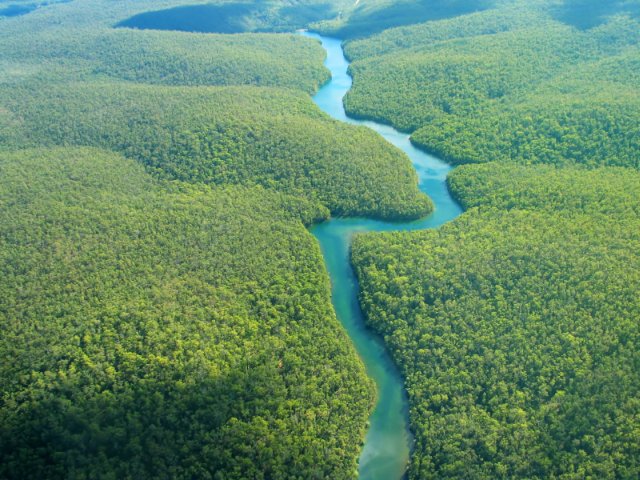
One mighty river now irrigates 40% of South America. This is the Amazon, the largest river on earth. From the Andes to the Atlantic Ocean it travels more than 6.5 thousand kilometers, carrying 1/5 of all the river water of our planet. 1.5 thousand kilometers before joining the ocean, its main channel is more than 15 kilometers wide. Interesting fact: not a single bridge has been built across the Amazon.

Every year the great Amazon overflows its banks, flooding forests over an area the size of England. At the peak of the flood, trees can be submerged 10 meters in water.
The Amazon and its tributaries irrigate the largest tropical forest on Earth. The Amazon jungle covers the space from the Andes to the Atlantic with an almost continuous carpet and is the wettest place on earth.
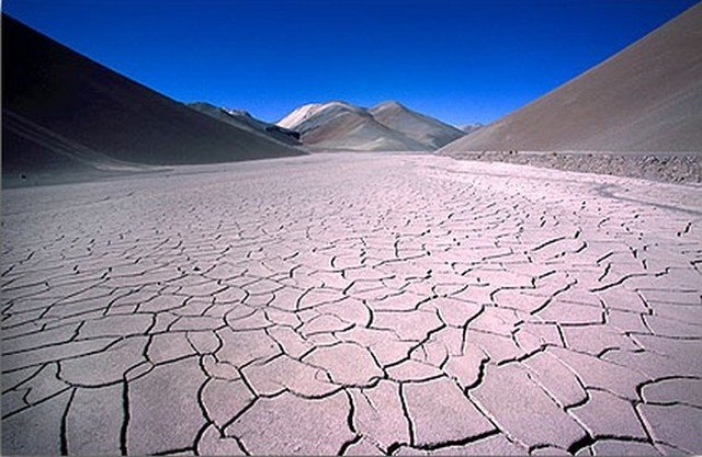
The Amazon lies to the east of the Andes, and powerful tropical rains pour over the jungle, feeding it with water. But the mountains act as an obstacle to the winds carrying moisture from the east, so that on the western side of the mountains there are places where not a drop of rain falls. Here is the driest desert in the world - the Atacama. This is a narrow strip between the mountains and the Pacific Ocean. The Atacama may not have rain for several years and the humidity level is zero. It’s hard to imagine how one can survive here, but some people manage to do it. The key to life for the desert is the Pacific Ocean. Every morning a blanket of fog, coming from the Pacific Ocean, spreads over the desert. Fog is almost the only source of water in the desert. This moisture condenses in the early morning on the spines of the cacti and on the lichens growing on the cacti. This water is the only life-giving moisture for the selfless inhabitants of Atacama. There is no more water in the desert.
Atacama is home to one of the most unusual places on the planet – the Valley of the Moon (Valle de la Luna). This place will resemble the lunar surface thanks to the unique formations of salt, sand and rocks scattered several million years ago by a nearby volcano. In the valley you can observe amazing lifeless landscapes and a sunset of unearthly beauty, which delights with its range of colors. This is where many science fiction films were filmed.
Believe it or not, there is a place that is statistically the rainiest place in the world. No, this article is not dedicated to London - there is a corner of the planet where there is much more rainfall, and it is located in the northeast of India - in the state of Meghalaya, in the city Mawsynram.
The rainiest place on the planet is India
The World Meteorological Organization station, located in Mawsynrama, has been recording rainfall since 1851. According to statistics, the annual precipitation rate is 11872 mm, which is almost 12 meters! There was even a world record for annual precipitation, amounting to 26,470 mm, which is several times more than in the period from August 1860 to July 1871, which was considered the rainiest period.

According to the data, the greatest amount of precipitation fell in 1985 and amounted to as much as 23,818 mm, and the driest year is considered to be 1980 - only 6,195 mm of precipitation fell. To make it easier to understand these figures, we note that, for example, the annual precipitation rate in Moscow is 691 mm. A couple of other Colombian places are vying for the championship of being the wettest place in the world, but the city of Mosinrem is not inferior to them.

Of course, it's only a matter of time until these cities and countries rank high on the scale of wettest and driest places in the world. After all, we observe climate change from year to year, and it is not yet known whether the leader will change next year.