
The largest mountain systems and ranges in Russia: the Caucasus, the Urals, Sikhote-Alin. Mountains: characteristics and types
Caucasus Mountains. From the Taman to the Absheron Peninsula, between the Black and Caspian Seas, stretches the Caucasus mountain system, consisting of the Ciscaucasia, the Main Caucasus Range and Transcaucasia.
Ciscaucasia can be divided into Western and Eastern. Western Ciscaucasia is flat and lowland. In its center lies the Stavropol Upland with heights of up to 832 m. To the southeast of the hill they rise separately standing mountains- laccoliths. The Eastern Ciscaucasia is occupied by a lowland that merges with the Caspian.
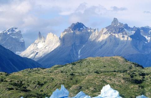
The Greater Caucasus consists of the Main Caucasus Range and ridges extending from it. The northern slope of the Main Range is flatter than the southern one. The highest peaks of the Greater Caucasus are Elbrus, Kazbek, Shkhara - more than 5 km above sea level. Many peaks of the Caucasus are covered with snow and glaciers. Karst caves are often found here.
Transcaucasia is located south of the Main Caucasus Range. It consists of the Colchis and Kura-Araks lowlands, separated by the watershed Suram ridge. To the south is the Lesser Caucasus mountain system,
In the Caucasus there are both very ancient rocks (gneisses, schists, marble, quartzites) and rocks of more recent eras. The Paleozoic is represented by granites, the Devonian - by shales, sandstones, and tuffs.
At the boundary between the Triassic and Jurassic, the Caucasus experienced a general uplift associated with the transition to Alpine folding, when the Caucasus turned into a high-mountainous country. Even in the Quaternary period, the volcanoes Elbrus, Kazbek, Aragats and others were active.
Ural mountains. This is a mountainous country, stretching from north to south along the border of Europe and Asia for more than 2000 km and separating two huge plains - East European and West Siberian. Southern border Ural - the valley of the Ural River - below the city of Orsk. The width of the Ural Mountains is from 60 to 150 km. The western foothills of the Urals gradually transform into the East European Plain and are called the Cis-Urals. In the east, the Urals ledge passes into the Trans-Urals.
The Urals are one of the old, heavily destroyed, low mountain ranges. This is a complex folded system that formed on the site of the vast Ural-Tien Shan geosyncline, which separated the East European and East Siberian platforms. Folds of the earth's crust formed in the area of the geosyncline at the end of the Carboniferous and beginning of the Permian periods. The sea existed on the Russian Platform throughout the Permian period.
Subsequently, external and internal forces mountain ranges were gradually destroyed. In Jurassic times, the leveled surface east of the modern Urals sank and was occupied by seas until the Paleogene. Based on relief, climate and vegetation, the Ural Mountains are usually divided into three parts: the Northern Urals (from the shores of the Kara Sea to 61° N), the Middle Ural (from 61 to 55° N) and Southern Urals(from 55° N to the Ural River).
In the Northern Urals, where its main peak is Mount Narodnaya (1894 m), there are small glaciers. Their formation is caused not so much by the height of the mountains as by the severity of the climate.
Middle Urals significantly lower than the Northern and Southern ones, it forms a kind of saddle in relation to them. Mountain passes in the southern part of the Middle Urals lie at an altitude of 300-400 m and are only slightly elevated above the neighboring areas of the East European and West Siberian Plains. That's why it was laid here most of railway lines connecting Europe and Asia.
In the Southern Urals, the highest peak is Yamantau (1646 m). It is located in its central part. From here to the south the mountain ranges decrease.
I consider these mountains to be real natural giants in our area. The Ural and Caucasus mountains are unique in their own way, they have rich wildlife and vegetable world, and are also a landmark of their lands. Answering the question about the highest of them, I also want to tell interesting features and the facts concerning these mountains.
Caucasus Mountains
This is a rather large mountain system that stretches between the Caspian Sea and the Black Sea. Considering the size of the mountains, they are divided into two systems: the Lesser Caucasus and, accordingly, the Greater Caucasus, which extends approximately 1,100 kilometers. The most famous peaks are Elbrus, which is five and a half kilometers away, and Kazbek (just under 5 km). By the way, the Caucasus Mountains are famous for their glaciers (about 2000) and constant snow. If we talk about the animal world, the Caucasus is home to:
- wild boars;
- mountain goats;
- chamois;
- golden eagles.
If we talk about the flora in these mountains, then it is definitely worth saying that 16 plant species originated in the Caucasus. Now I want to talk about the highest point, which is located on the top of Elbrus (5 thousand 642 meters).
Ural Mountains: characteristics and height
This system The mountain ranges between the West Siberian and East European plains and occupies the territory of Russia and Kazakhstan. The length is greater than that of the Caucasus, namely 2000 kilometers. Important feature The Urals are rich in mineral resources, of which about 48 species are represented. If you find yourself within the Ural Mountains, you can observe the crystalline clean rivers and the streams that stretch there. For example: the Pechora River, the Ural, also the Kama and Belaya. You can also highlight large valleys and characteristic sharp relief forms in the Urals. If we talk about the height of these mountains, then it is more modest than those of the Caucasus. Its values do not exceed 1900 meters.

Now I can say for sure that the Caucasus Mountains are higher than the Ural Mountains, because they highest point twice as much. But, nevertheless, it can be noted that the Ural Mountains also have their advantage - their length.
The Caucasus is a mountain system located in Eurasia between the Black and Caspian seas. The mountain range extends 1,100 km from the Taman Peninsula and Anapa to Absheron Peninsula near the city of Baku.
This territory is usually divided according to several criteria: into the Greater and Lesser Caucasus, as well as into the Western (from the Black Sea to Elbrus), Central (from Elbrus to Kazbek) and Eastern (from Kazbek to the Caspian Sea). The mountain system reaches its greatest width in the central part (180 km). The mountain peaks of the Central Caucasus are the highest on the Main Caucasus (Watershed) Range.
The most famous mountain peaks of the Caucasus are Mount Elbrus (5642 m) and Mount Kazbek (5033 m). Both peaks are stratovolcanoes. Moreover, Kazbek is considered extinct, which cannot be said about Elbrus. Experts' opinions on this matter vary. The slopes of the two highest mountains of the Caucasus are covered with snow and glaciers. The Central Caucasus accounts for up to 70% of modern glaciation. Over more than a century of observations of the glaciers of the Caucasus, their area has decreased significantly.
North from the foot Greater Caucasus stretches an inclined plain that ends in the Kuma-Manych depression. Its territory is dissected by side ridges and river valleys. The largest rivers in this territory can be considered the river. Kuban and Terek. To the south of the Greater Caucasus are the Colchis and Kura-Araks lowlands.
The Caucasus Mountains can be considered young. They were formed during the Alpine folding era approximately 28-23 million years ago. Their formation is due to the northward movement of the Arabian lithospheric plate onto the Eurasian plate. The latter, pressed by the African plate, moves several centimeters per year.
Tectonic processes in the depths of the Caucasus continue to this day. Geological structure Elbrus indicates great activity of the volcano in the recent past. Several powerful earthquakes occurred in the Caucasus in the 20th century. The most destructive earthquake was in Armenia in 1988.
Seismic stations operating throughout the Caucasus annually record several hundred tremors. Experts say that some parts of the Caucasus ridge are “growing” by several centimeters per year.
Caucasus in Europe or Asia?
This issue should be considered more politically and historical aspects. The Caucasus Mountains are located in the center of the Eurasian plate, so the division can only be conditional. The border between Europe and Asia was proposed by the Swedish officer and geographer F. Stralenberg in 1730. The border that ran along the Ural Mountains and the Kuma-Manych depression was accepted by many scientists.
Despite this in different time Several alternative proposals were proposed that justified the division of Europe and Asia along the Caucasus Mountains. Despite the ongoing controversy, Elbrus is still considered the highest point in Europe. The history of the region suggests the special position of the Caucasus at the crossroads between European and East Asian cultures.
The highest mountains of the Caucasus
- Elbrus (5642 m). KBR, KCR. Highest point in Russia
- Dykhtau (5204 m). CBD
- Koshtantau (5122 m). CBD
- Pushkin Peak (5100 m). CBD
- Dzhangitau (5058 m). CBD
- Shkhara (5201 m). CBD. Highest point of Georgia
- Kazbek (5034 m). Highest point North Ossetia
- Mizhirgi Western (5022 m). CBD
- Tetnuld (4974 m). Georgia
- Katyntau (4970 m). CBD
- Shota Rustaveli Peak (4960 m). CBD
- Gestola (4860 m). CBD
- Jimara (4780 m). Georgia, North Ossetia
- Ushba (4690 m). Georgia, North Ossetia
- Gulchitau (4447 m). CBD
- Tebulosmta (4493 m). The highest point of Chechnya
- Bazarduzu (4466 m). The highest point of Dagestan and Azerbaijan
- Shan (4451 m). The highest point of Ingushetia
- Adai-Khokh (4408 m). North Ossetia
- Diklosmta (4285 m). Chechnya
- Shahdag (4243 m). Azerbaijan
- Tufandag (4191 m). Azerbaijan
- Shalbuzdag (4142 m). Dagestan
- Aragats (4094). Highest point of Armenia
- Dombay-Ulgen (4046 m). KCR
How many five-thousanders are there in the Caucasus?
Mountains whose height exceeds five kilometers are usually called Caucasian five-thousanders. From the list presented above, it is clear that The Caucasus has eight mountains of five thousand meters«:
- Elbrus(5642 m) is a dormant volcano and the highest mountain in Russia. The mountain consists of two peaks, Western (5642 m) and Eastern (5621 m), connected by a saddle (5416 m).
- Dykhtau(5204 m) - mountain peak of the Side Range of the Greater Caucasus. The mountain consists of two peaks (both over 5000 m high), connected by a steep, narrow saddle. The first ascent of the mountain took place in 1888. Today, about ten routes with difficulty from 4A (according to the Russian classification) have been laid to the top of Dykhtau.
- Koshtantau(5122 m) is a mountain peak on the border of Bezengi and the mountainous region of Balkaria.
- Pushkin Peak(5100 m) - being part of the Dykhtau mountain range, it is a separate peak. Named in honor of A.S. Pushkin on the 100th anniversary of his death.
- Dzhangitau(5058 m) is a mountain peak in the central part of the Greater Caucasus. There are three peaks in the Dzhangitau massif, all of which are more than five kilometers high.
- Shkhara(5201 m) is a mountain peak of the Central Caucasus that is part of the Bezengi Wall.
- Kazbek(5034 m) - an extinct stratovolcano, the easternmost five-thousander of the Caucasus. The first ascent of the mountain was made in 1868.
- Mizhirgi Western(5022 m) - a mountain peak as part of the Bezengi wall. The name of the mountain is translated from Karachay-Balkar as “connecting”.
The time period for the formation of mountains is estimated at millions of years. Their occurrence occurs due to the collision of formed earth's crust tectonic plates.
Andean Cordillera
Name the most long mountains in the world, can you do it? Without thinking, you will probably remember the Andes. They are located in South America. Their name is translated from the Inca language as “copper mountains”. They have no equal on our planet.
For those who do not know what the longest mountains in the world are, it is worth saying that the length of the Andean Cordillera is unprecedented. It is equal to nine thousand kilometers.
This long mountain range originates from Caribbean Sea. At the same time, he reaches Tierra del Fuego itself.
Highest peak in the Copper Mountains
The process of formation of the Andean Coldillers continues to this day. Sometimes the mountain range makes itself felt through volcanic eruptions. There are often earthquakes there. The formation process ends with the uplift of rocks.

Huge folds of stone rise to impressive heights.
Mount Aconcagau is considered the highest peak of the Andean Cordillera. Its maximum elevation is 6962 m.
Main characteristics of the Andean Cordillera
If you are asked the question: “Name the longest mountains in the world and describe them,” then it is worth mentioning another parameter. The maximum width of the chain of these unique ridges is seven hundred and fifty kilometers. This value was recorded in the Andean Highlands in the Central Andes. There are places where the width of the Copper Mountain is five hundred kilometers.
But big square The Andean Coldirier is occupied by a plateau. It is called Pune. The height of the mountain range here is on average about four kilometers.
According to experts, Copper Mountain- relatively young education. The process of its formation was completed about several million years ago. Fossils began to emerge in the Precambrian and also in Paleozoic period. It was then that land areas began to appear in place of the vast ocean. And for a long period, the area where the Andes are currently located was either a sea or a piece of land.
The longest ridge in the world also serves as a very large watershed between the oceans. IN Copper Mountain The source of the famous river is located there. Its tributaries also originate there. The Andean Cordillera is the beginning of many large rivers The South American continent, which flows through Paraguay, Orinoco and the state of Parana.
Climatic conditions
If your task is concluded in the question: “Name the longest mountains in the world and temperature zones, in which they are located,” then it is worth mentioning their insulating purpose. For the mainland, the Andean Coldiriers serve as a climate barrier. The fact is that they perfectly isolate the land from the influence of the Atlantic from the west. They protect the continental ridges and from Pacific Ocean from the east.

Considering the length of the mountain chain, it is not at all surprising that the Andes are located in more than one climate zone. These are subtropical temperate and southern tropical, equatorial, as well as southern and northern subequatorial. The mountain range stretches through all six of the above climatic zones. In this regard, in different parts The chain of ridges radically differs from the existing landscape. The difference is also observed due to the loss various quantities precipitation. If on western slopes this value is up to ten thousand millimeters, then in the south it is much less.
Separation by relief
If you need to answer the question: “Name the longest mountains in the world and their main components,” then you should describe the regions into which the Andean Cordillera is divided. Based on the relief, the Andes are divided into central, southern and northern. Each region has its own ranges. The Northern Andes include the Caribbean, Ecuadorian, and Northwestern Andes. The main mountains are separated by the depressions of two rivers - the Magdalena and the Cauca. In these same zones there are a large number of volcanoes. One of them is Wila. Its height is 5750 m. But the Ruiz volcano reached 5400 meters.
In the Ecuadorian Andes there is a whole chain of high volcanoes. The most notable giant is Chimborazo. Its the most high point- 6267 m. A little lower than Cotopaxi (5896 m). This mountain chain passes through the territory of seven states located on the South American continent. Among them are Colombia and Ecuador, Venezuela and Bolivia, Peru and Chile, as well as Argentina. The highest point of the Andes is at 6769 m. It belongs to Mount Huascaran.
The Southern Andes are divided into Chilean-Argentine and Patagonian. The highest peak in this part is Tupungato. It rises to 6800 m. A little lower is Mount Medsedario. Its height is 6770 m.
Picturesque slopes
If you are asked: “Name the longest mountains in the world and describe it unique place", then you should talk about the extraordinary beauty of the chain of ridges. Moreover, this mountain system in each state has its own zest. Thus, in the Venezuelan Andes, shrubs and deciduous forests. The slopes from the central to the northwestern part of the mountain range boast a different landscape. They are covered with equatorial and tropical forests. Here you can find bananas and ficus trees, cocoa trees and palm trees, vines and bamboos. There are also areas of the Andean Cordillera that are covered with lifeless rocky spaces or moss swamps. And everything that is above four and a half kilometers is snow and eternal ice.
Animal world
The Andes are distinguished by a wide variety of fauna. They are the habitat of alpacas and llamas, and here you can see relict spectacled bear, sloths, blue foxes, chinchillas and hummingbirds. In other words, those representatives of the animal world that in Russia are found only in the zoo.

The Andes are considered to be home to more than nine hundred species of amphibians, six hundred species of mammals and two thousand species of birds. Local rivers also have a large variety of fish (about 400 species).
Ural Mountains
What are the longest mountains in Russia? Ural. This mountain system stretches between the West Siberian and East European plains. The length is almost 2000, and with Mugodzhary and Nai Khoi - 2600 km.

What are the longest width parameters? The minimum is 40 km. In some places the width of the mountain range reaches 150 km.
History of origin
The formation of the Ural ranges occurred in the late Paleozoic period. This was an era of intense mountain building. The formation of the massif itself began about three hundred and fifty million years ago. It was late Devonian. The process ended almost two hundred million years ago.
IN Ural zones Deformed and often metamorphosed rocks rise above the surface mountain type. They belong to the Paleozoic era.
Geographical zones
The Ural massif is conventionally divided into five parts. There are Southern and Middle. There are Northern and Subpolar, as well as Polar.
The widest part of the mountain range is the Southern Urals. Its eastern slopes are covered with forest-steppe and big amount lakes The landscape of the western side of the southern mountain range is a steppe. A little to the north it is replaced by forests.
The Middle Urals are the lowest and narrowest part of the mountain range. The mountain slopes in this area are covered with coniferous forests.
The climate in this area is characterized by a more severe climate. The mountain slopes in this area are covered with forests, in which there are many berries and mushrooms.
The highest region is the Subpolar Urals. In its central part is the Narodnaya Peak. It rises to 1894 m. A little lower than it, also in Subpolar Urals, there is Mount Karpinsky. Its height is 1876 m.
Located in the tundra zone Polar Urals. In this area of the mountain range there is a decrease in its height and width. characterized by a harsh climate. Duration summer period in this area it is small - only a month (from mid-July to mid-August).
Caucasus Mountains
This array is divided into two systems. These include the Greater and Lesser Caucasus. The mountain system extends between the Azov, Black and Caspian seas.
If you are asked the question: “Name the longest mountains located in the south of Russia,” then without hesitation you should name the Caucasus. Their formation was completed in the Tertiary period.

What is the length of the Greater Caucasus? It stretches for more than one thousand one hundred kilometers. This beautiful place, rich in diverse flora and fauna.
You can meet wild boars, chamois and golden eagles. The massif is the habitat of the rare Caucasian leopard.
Russia is a huge country. It is not surprising that it contains all the terrain that is found in nature. Among the plains and steppes, mountain ranges and peaks occupy a special place. They attract travelers and researchers, scientists and tourists, archaeologists and climbers. What mountains are there in Russia? What you should pay attention to?
In contact with
Origin
Regions mountainous areas are formed as a result of complex processes. Tectonic crushing, faulting and faulting of rocks occur in the earth's crust. They are carried out continuously during the entire existence of the planet, in ancient time eras such as the Paleozoic, Mesozoic or Cenozoic. Those who are located in the Far East, Kamchatka and the Kuril Islands are considered young. These areas often experience seismic activity and volcanic eruptions.
In the European part of Russia there is large plain, which has geographical boundary in the east in the form of . These are unique natural sculptures that evoke national pride.
Interesting! Only in the Urals there is nature reserve, protecting mineralogy. The Ilmensky place has a huge variety of minerals, unique and amazing in their structure and structure.
There are many tourist bases in the Urals, they are located ski resorts. Climbers conquer these majestic heights.
Variants of the Russian mountains
- Baikal region and Transbaikalia;
- Altai;
- Sayan Mountains;
- Verkhoyansky and Stanovoy ridges;
- Chersky ridge.
Each of the areas is interesting and beautiful, the names of the mountains in their composition are unique and owe their origin to the peoples who inhabit the surrounding territories. These lands beckon harsh conditions, tests for body and spirit. Altai is one of the most popular destinations for tourists. But the Chersky ridge is on the map, but so far little has been studied, but experts suggest that it will also become attractive place for travelers.

Diversity of territories
The Far East is a region consisting mainly of mountainous area. The southern territorial part consists of medium and low ones, but in the north there are high ridges. Highest point Far East – Klyuchevskaya Sopka, this is a volcano with a height of 4750 m.
The mountains in this region are constantly growing; they are located at the junction of plates that are in motion, which is why there are many volcanoes. Besides them there are unique object, for which it is worth going to Kamchatka - the Valley of Geysers.
Important! Sikhote-Alin, located in the Primorye region, is part of world heritage. This system is rich not only in the diversity of flora and fauna. This point of Russia on the map is the birthplace Far Eastern leopard and the Amur tiger.
Caucasus
The Caucasus deserves separate description. This massif extends from the Black to the Caspian, its length is more than 1200 km. The Caucasus Range is divided into the Northern part and Transcaucasia.
Height Caucasus Mountains fluctuates along the entire length of the ridge. It is he who has the highest point in the whole country and Europe– this is Elbrus. The mountain was formed as a result of a volcanic eruption. It has an altitude of 5600 m above sea level. Elbrus is located in such a place that it can be seen from all sides. Travelers approached it back in the early 19th century. At its peak, the temperature does not rise above -14 degrees. Snow falls on the mountain constantly, which makes its snow cap ideal. This peak feeds the two largest ones - Kuban and Terek.

In the Greater Caucasus there are three highest mountains Russia:
- Elbrus;
- Dykhtau;
- Kazbek.
Interesting! In addition to the Caucasus Mountains, Kamchatka and Altai are famous for their large hills, among them: Klyuchevskaya Sopka, Belukha, Ichinskaya Sopka.
10 high mountains
A little more detail about each of the largest hills:
- It’s already clear about Elbrus; it is an inactive volcano, part of national park. Its height is 5642 meters.
- Dykhtau ranks second in size among mountain peaks countries. This mountain, part of the Caucasus Range, rises to 5200 m. The ascent to this peak was first carried out only in 1888.
- The country's third largest mountain is located on the border of Russia and Georgia. This is Pushkin Peak. It rises near Dykhtau in the center of the Caucasus ridge. Its conquest took place in 1961. It is interesting that this ascent was made not by professionals, but by football players of the Spartak club. The height of the peak is 5100 meters.
- A little lower, namely a hundred meters, rises Kazbek. It is also related to the Greater Caucasus, located in its lateral part in the Khokh mountain range. Three London climbers conquered this peak back in the mid-19th century.
- Near the border of Georgia and Kabardino-Balkaria there is the fifth highest point in size in Russia called Gestola. At its top, glaciers have accumulated that date back to the Paleozoic era. The most famous of them is Adishi.
- Sixth in the top ten is the peak of Shota Rustaveli. Although the peak bears the name on the map famous person Georgian origin, but still belongs to the Russian part of the Caucasus. The peak stands on the border, no wonder both countries claim rights to it. The mountain has 4895 meters.
- A little lower (4780 meters) is Mount Jimara. It is located in Alanya, near the border of Russia and Georgia. Again, this is part of the Greater Caucasus.
- In ninth place is Mount Saukhokh, again from the Greater Caucasus, located in North Ossetia. The height of the peak is 4636 meters. It belongs to the unconquered peaks, just like Kukurtli-Kolbashi. This mountain completes the list of the ten largest peaks in Russia, its height is 4324 meters.
Interesting! So far no one has conquered rock formations, located in 8th, 9th and 10th places on the list. This may prompt travelers to new exploits.
Lowest mountains
In addition to the highest mountain peaks, it is interesting to know the rating of the lowest ones. Such a concept as the most low mountain, very difficult. It turns out that it is not so easy to name it. Only those things that are higher can be called mountains.